INTRODUCTION OF SPECIAL ORDINANCES
By the City Plan Commission:
SPECIAL ORDINANCE NO. 9, 1947.
AN ORDINANCE annexing certain contiguous territory to the City 01 Indianapolis, Indiana; and fixing a time when the same shall take effect.
BE IT ORDAINED BY THE COMMON COUNCIL OF THE CITY OF INDIANAPOLIS, INDIANA:
Section 1. That the City of Indianapolis be and the same is . hereby extended so as to include the following described contiguous territory, which is hereby annexed and made a part of the territory constituting the City of Indianapolis, in Marion County. Indiana and is described as follows to-wit:
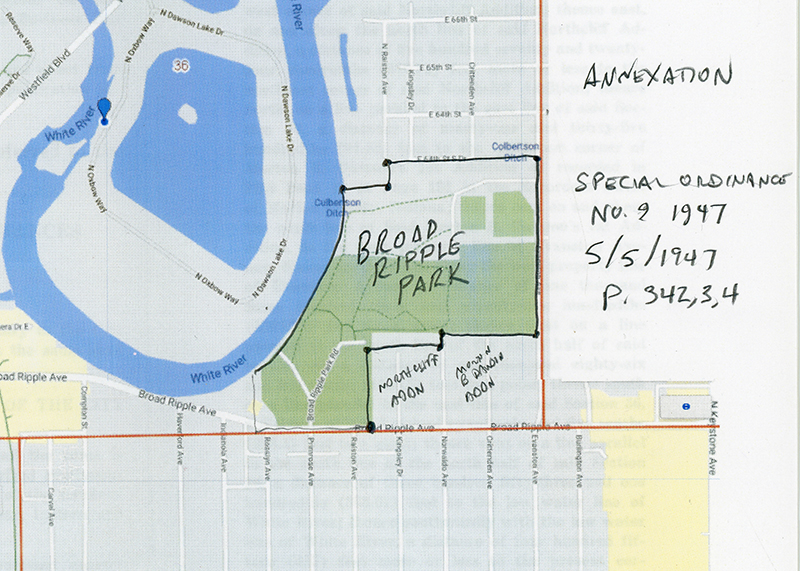
Said annexed territory being located in the southeast quarter of Section 36, Township 17 North, Range 3 East in Marion County, Indiana, and being more particularly described as follows:
Beginning at a point in the present corporation line on Broad Ripple Avenue (formerly East 63rd or 2nd St.) said point being located one thousand two hundred twenty-eight and ninety-two hundredths (1228.92) feet west of the east line of said Section 36; thence north on and along the west line of North-cliff Addition, as recorded in Plat Book 18 at Pages 165 and 166 in the Recorders Office 01 Marion County; Indiana, a distance of five hundred seventy and nine tenths (570.9) feet more or less to the northwest corner of said Northcliff Addition; thence east, on and along the north line of said Northcliff Addition, a distance of five hundred seventy and twenty-four hundredths (570.24) feet more or less to the northeast corner of said Northcliff Addition; thence north, on a line parallel to the east line of said Section 86, a distance of ninety-one and thirty-five hundredths (91.35) feet to the northwest corner of Morton B. Dawson's 1st Addition as recorded in Plat Book 19 at Page 151 in the Recorders Office of Marion County, Indiana; thence east on and along the north line of Said Morton B. Dawson's 1st Addition, to the west property line of Evanston Aye-flue; thence north on and along the west property line of Evanston Avenue a distance of one thousand three hundred three and seventy-five hundredths (1303.75) feet to a point; thence west on a line parallel to the south line of the north half of said Section 36, a distance of one thousand eighty-six and five tenths (1086.5) feet to a point; thence south on a line parallel to the east line of said Section 36, a distance of two hundred twenty-six and five tenths (226.5) feet to a point; thence west on a line parallel to the south line of the north half of said Section 36, a distance of three hundred fifty-three and one hundredths (353.01) feet to the low water line of White River; thence southwardly with the low water line of White River, a distance of four hundred fit-teen (415) feet more or less to the present corporation line of the City of Indianapolis; thence south, southeastwardly, southwestwardly and eastwardly along the present corporation line as established and described in Section 125 of General Ordinance 121, 1925, to the place of beginning.
Said Ordinance No. 121. 1925 being the municipal code of the City of Indianapolis.